"...from these honored dead we take increased devotion to that cause for which they gave the last full measure of devotion - that we here highly resolve that these dead shall not have died in vain - that this nation, under God, shall have a new birth of freedom - and that government of the people, by the people, for the people, shall not perish from the earth."
Abraham Lincoln's Gettysburg Address (November 19, 1863)
I have made trips out to Gettysburg National Military Park each of the past three years to photograph the Union and Confederate monuments and the historic battlefields where so many men lost their lives or were were seriously wounded. The Civil War was America's bloodiest war, and Gettysburg was the bloodiest battle of that war. Additionally, from all I have read and learned, Abraham Lincoln embodied qualities of true leadership: intelligence, empathy, humor, pragmatism, decency, and humility. It is inspiring to see (and photograph) where he delivered the Gettysburg Address, in which he reminded us of our core American values of equality and democracy. I am posting this on November 19th, the anniversary of that historic speech.
In this post, I will A) list and describe some of my favorite photography locations in and around Gettysburg National Military Park; B) make a few suggestions regarding photography at the park; and C)present some of my photographs of Gettysburg National Military Park in order to give a feeling of the park, and some photographic possibilities. To get oriented, here is a useful MAP OF GETTYSBURG NATIONAL MILITARY PARK.
My most recent trip to Gettysburg was in early September of 2020. During the prior four months, Confederate monuments were very much in the news, following the death of George Floyd. Many historians argue that the monuments glorify the Confederacy and sanitize history by failing to mention slavery as a central cause of the war. Visiting the Confederate monuments, I saw words like "valor," "heroism," and "courage," but there was a notable absence of the word "slavery." It is my understanding that the National Park Service planned to install new panels at Gettysburg's Confederate monuments to give greater historical context regarding the battle, as well as the significance of the monuments themselves (connections between Confederate monuments and the Jim Crow era; resistance to the civil rights movement, the spread of "Lost Cause" mythology following the Civil War, etc.).
FAVORITE PHOTOGRAPHY LOCATIONS:
Cemetery Hill (off of Baltimore Street) - This area has several equestrian monuments to Union generals, including Major General Oliver Otis Howard as well as Major General Winfield Scott Hancock. Additionally, there are cannons perched on a hilltop overlooking a scenic landscape. This is a great sunrise and early morning location.
Little Round Top - This is an elevated location from which many areas of the park and battlefield can be seen (e.g. "The Devil's Den"). It is a prime photography spot in the early morning and late afternoon. The monument to Union Brigadier General Gouverneur Kemble Warren is a compelling photographic subject, from a variety of angles. Additionally, one can compose interesting images of cannons situated well above the surrounding countryside.
Gettysburg National Cemetery and Lincoln's Gettysburg Address Memorial (Taneytown Road) - There are many interesting things to photograph, including the bust of Lincoln, details of the Gettysburg Address plaque, Soldiers National Monument, and different parts of the cemetery itself.
Seminary Ridge (West Confederate Avenue) - There countless opportunities for dramatic photographs of Confederate cannons, the stone fence, trees and open fields. Additionally, as you drive along the one-way road, there are several notable Confederate state monuments, including (in order that you see them) North Carolina, Tennessee, Virginia and Louisiana. The North Carolina monument includes a statue by Gutzon Borglum (who designed Mount Rushmore). The Virginia Memorial includes a tall, equestrian statue of Robert E. Lee, above another statue of soldiers from Virginia. A short walk from the Lee statue is a tribute to "Woolfolk's Battery," one of the starting points of the futile Confederate attack on the battle's third day. A short drive south of the Virginia memorial, near the Amphitheater, there is a equestrian statue of Confederate Lieutenant General James Longstreet.
Cemetery Ridge (Hancock Avenue) - As you drive north on Hancock Avenue, Union cannons point over the fields. There are many notable Union landmarks and monuments here, with infinite photographic possibilities. These include (in the order that you see them, as you drive on the one-way road): The First Minnesota Infantry Regiment; the State of Pennsylvania Monument; The "Copse of Trees" marking the "High Water Mark of the Rebellion;" and the area known as "The Angle", which has many notable Union statues including an equestrian monument to Major General George Gordon Meade; the monument to the 72nd Pennsylvania Volunteer Infantry Regiment; the monument for the First Pennsylvania Cavalry Regiment; etc. I have found the area near "The Angle" to be a wonderful spot both during and after sunset.
The Devil's Den - The formation of rocks and boulders make an interesting photographic subject. Additionally, at the top of the Devil's Den, the Monument to the 4th New York Independent Battery ("Smith's Battery") has a dramatic look with late afternoon light.
Miscellaneous other locations: In addition to the primary spots listed above, there are many smaller, but significant landmarks, which provide interesting photographic subjects. A few examples include: historic farms; the Sachs Covered Bridge; McPherson's Ridge (and the monument to Major General John Fulton Reynolds); and monuments to assorted regiments (e.g. 96th Pennsylvania Volunteer Infantry Regiment, on Wheatfield Road).
SUGGESTIONS AND CONSIDERATIONS FOR PHOTOGRAPHY AT GETTYSBURG NATIONAL MILITARY PARK:
**Try to catch a sunrise and/or sunset. Dramatic light adds immeasurably to any Gettysburg photograph. Cemetery Hill is a wonderful spot before and during sunrise. Cemetery Ridge (Hancock Avenue) is a great spot at sunset. "The Angle" provides loads of great opportunities just after sunset, if you are fortunate to have a colorful pink sky. Little Round top is terrific in the early morning, as well as at sunset.
**Silhouettes: Try to capture a statue or monument against a dramatic sky. If you meter on the sky, and purposely "underexpose" the subject, it will appear as a silhouette.
**When considering how much gear to carry, its good to remember that most spots are only a short walk from parking locations.
**Expriment with different apertures. For classic landscape shots, you may want a wide depth of field, but for for a portrait (e.g. of a statue), you may want the background to be purposefully blurry.
**Look for interesting details which tell a story. For instance, while shooting the plaque commemorating the Gettysburg Address, I tried to highlight the phrase "created equal" which was surrounded by words "liberty" and "Civil War."
**In addition to the permanent features of the park, try to capture unique moments. Each trip to Gettysburg offers new possibilities. For instance, on my first trip to Gettysburg, someone had left a red rose in front of the North Carolina memorial. On my most recent trip, a clearing rain shower gave way to a colorful rainbow which partially framed a monument at McPherson's Ridge. The late afternoon sun peeking out from behind a monument can provide a sunburst, which adds a dramatic visual element to the image.
CEMETERY HILL (Baltimore Street)
 |
Monument to Major General Oliver Howard, before Sunrise.
East Cemetery Hill.
|
 |
Cannons on East Cemetery Hill, just before sunrise.
|
 |
East Cemetery Hill with Monument to Major General
Oliver Howard, before Sunrise.
|
|
 |
East Cemetery Hill with Winfield Scott Hancock
Monument, after sunrise. |
LITTLE ROUND TOP
 |
Monument to Brigadier General Gouverneur Kemble Warren,
on Little Round Top, with fall foliage, distant hills,
and early morning light. |
 |
Silhouette of Monument to Brigadier General Gouverneur
Kemble Warren, on Little Round Top, with State of Pennsylvania
Monument in the distance, soon after sunrise.
|
 |
Cannon on Little Round Top, overlooking the Devil's Den, and other sections of the Gettysburg Battlefield.
|
 |
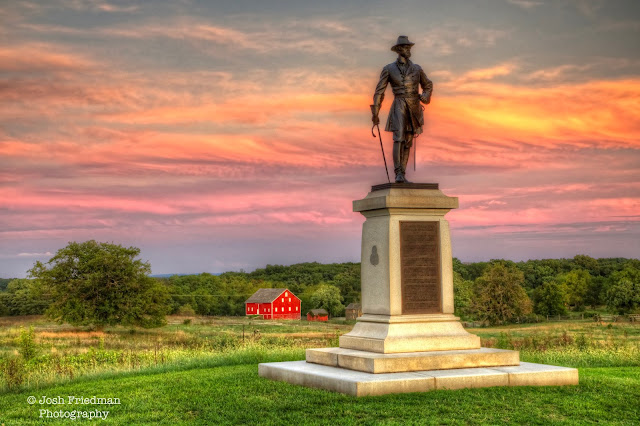
Monument to Brigadier General Gouverneur Kemble Warren,
on Little Round Top, with the setting sun. |
GETTYSBURG NATIONAL CEMETERY AND
LINCOLN'S GETTYSBURG ADDRESS MEMORIAL
(Taneytown Road)
 |
Lincoln's Gettysburg Address Memorial (with quote
from the address), at the Gettysburg National Cemetery. |
 |
| Detail of plaque with quote from Gettysburg Address, at Lincoln's Gettysburg Address Memorial. Gettysburg National Cemetery. |
 |
Soldiers' National Monument, at Gettysburg National Cemetery, with dramatic late afternoon clouds. |
 |
| Graves and cannons at Gettysburg National Cemetery. |
SEMINARY RIDGE (West Confederate Avenue) |
| Cannon on West Confederate Avenue in snow. |
 |
Detail of the North Carolina State Monument with a rose.
West Confederate Avenue
 | Sculpture by Gutzon Borglum at the North Carolina State Monument,
West Confederate Avenue. |
|
 |
Cannon on West Confederate Avenue, with late afternoon sun
(near the State of Tennessee monument). |
 |
| State of Tennessee Monument on West Confederate Avenue. |
 |
| Cannon on West Confederate Avenue, with late afternoon clouds. |
 |
Statue of Robert E. Lee and his horse, Traveller,
at the Virginia Monument. West Confederate Avenue. |
 |
| State of Louisiana Monument with late afternoon clouds, on West Confederate Avenue, across from Pitzer’s Woods. |
 |
Detail of the State of Louisiana Monument, on
West Confederate Avenue, across from Pitzer’s Woods. |
CEMETERY RIDGE (Hancock Avenue)
 |
Cannon at sunset along Cemetery Ridge (South Hancock Avenue,
near State of Pennsylvania Monument.
|
 |
Monument to the First Minnesota Infantry Regiment,
with clearing afternoon storm clouds (South Hancock Avenue). |
 |
Silhouette of Monument to the First Minnesota Infantry Regiment,
with clearing afternoon storm clouds (South Hancock Avenue). |
 |
State of Pennsylvania Monument in late afternoon
light (South Hancock Avenue). |
 |
| Statue near the "Copse of Trees" marking the "High Water Mark of the Rebellion," just south of the Angle, on Cemetery Hill. |
 |
The monument to Major General George Gordon Meade,
on Cemetery Ridge, at "The Angle." |
 |
A Union cannon, just after sunset, at
"The Angle" on Cemetery Ridge.
|
 |
Monument to the First Pennsylvania Cavalry Regiment,
just after sunset, at "The Angle." |
 |
Monument to Brigadier General Alexander Webb,
just after sunset, at "The Angle" on Cemetery Hill. |
 |
Monument to the72nd Pennsylvania Volunteer
Infantry Regiment, at The Angle, after sunset. |
THE DEVIL'S DEN
 |
Boulders at the Devil's Den
|
 |
Monument to the 4th New York Independent Battery
("Smith's Battery) at top of Devil's Den |
 |
Monument to the 96th Pennsylvania Volunteer Infantry Regiment,
on Wheatfield Road, close to "The Devil's Den." |
 |
Sherfly Farm, seen from Sickles Avenue, off of
Wheatfield Road, near "The Peach Orchard."
|
 |
| Sachs Covered Bridge, on Waterworks Road. This is not part of the park, but it is a short drive from the NPS Amphitheater. Union troops crossed the bridge on the way to Gettysburg, and Confederate troops retreated across the bridge after the battle. |
 |
Equestrian monument to Major General John Fulton Reynolds,
at McPherson's Ridge (on Route 30), with a late afternoon rainbow. |


